
R S Tejus:
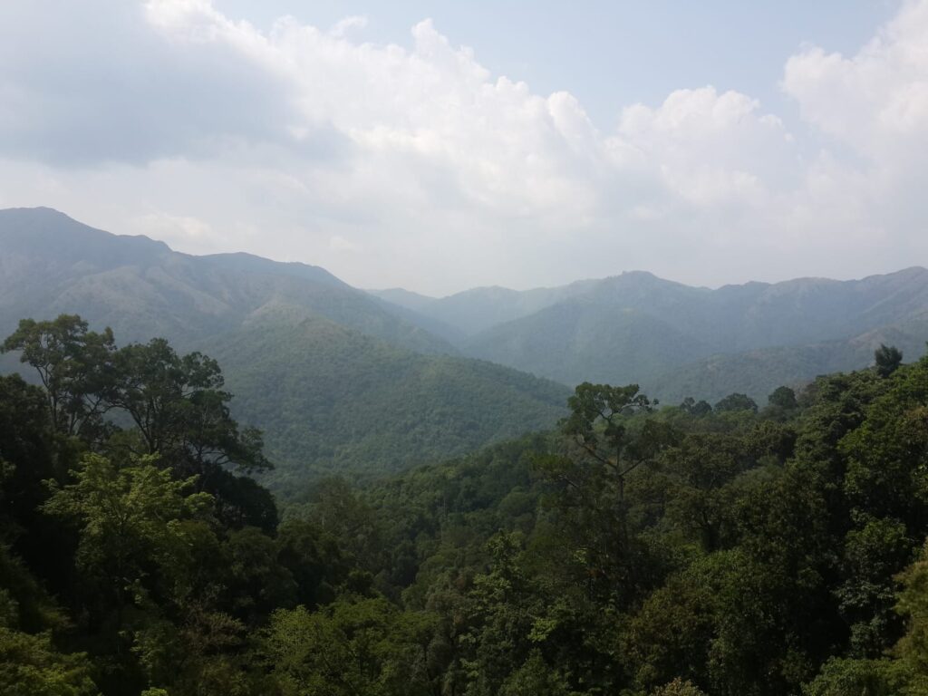
Karnataka is not only losing its forests only to one giant dam, one huge mine, or one single mega project but also the destruction is happening in a slower, quieter, and more dangerous way. Each cleared proposal when looked at in isolation seems very small but when hundreds of proposals are looked at collectively – they reveal the true picture of massive ecological destruction.
The Minutes of Meeting (MoM) of
– Dated 19th Dec 2025, minutes of 87th meeting of the standing committee of the National Board for Wildlife.
– Dated 7-8-2025 3rd meeting of the Standing committee of the State Board for Wildlife.
– Dated 5-11-2025 4th meeting of the standing committee of the State Board for Wildlife.
-Dated 12-3-2026 National Board of Wildlife Notification.
The above documents reveal the following facts and information very clearly:
A telecom tower inside a sanctuary.
A power line through a tiger landscape.
A drinking water pipeline across protected forest.
A road widened near a sanctuary.
A railway line pushed through a fragile wildlife area.
A canal survey inside a sanctuary.
An “upgrade” inside a national park.
Each proposal may look small when seen alone. Each meeting may look routine. Each file may look technical. But when all the Karnataka entries from the above four mentioned documents are brought together, the real picture becomes impossible to ignore.
Karnataka’s forests are being opened up again and again for roads, cables, towers, pipelines, electric lines, railway works, canal-linked activity, and utility infrastructure. A few proposals were rejected. A few were deferred. But the larger pattern is deeply disturbing: most of the pressure is still moving in one direction – into the forests.
If this continues for a few more years, Karnataka’s remaining tiny 4% of wild landscapes will not be destroyed by one sudden blow. In fact, they will be worn down bit by bit, until very little remains truly intact.
What the combined documents reveal?
Taken together, the four documents show repeated project pressure on protected areas (PA) and wildlife landscapes across Karnataka including:
- Shettihalli Sanctuary
- Mookambika Sanctuary
- Sharavathi Valley Sanctuary
- Kali Tiger Reserve
- Kudremukh National Park
- BRT Tiger Reserve
- Malai Mahadeshwara Hills Sanctuary
- Cauvery Sanctuary
- Bannerghatta National Park
- Someshwara Sanctuary
- Ranganathittu Sanctuary & ESZ
- Bukkapatna Sanctuary
- Rangayyanadurga Sanctuary
- the Tinaighat–Castlerock–Karanjol railway landscape
- a proposed Leopard Conservation Reserve landscape in Kalaburagi
The various types of projects repeatedly appearing in these records include:
4G towers
communication posts
optical fibre cable lines
underground and above-ground power lines
electrification works
drinking water pipelines
check dam augmentation
road widening and road improvement
metro power cable work
railway doubling
canal-related soil investigation
upgrading of old transmission lines
These proposals are not random. There is a pattern of repeated intrusion into protected landscapes.
However, forests are not feeling these projects separately. They are feeling them together.
This is the biggest truth that comes out of the four documents.
On paper, many of the diversions look small. Some are 0.0186 hectares. Some are 0.02 hectares. Some are less than one hectare. That is how these projects are often made to look harmless.
But a forest does not experience projects the way a file does.
The forest does not say: this is only one tower.
A tiger does not say: this is only one cable.
A bird does not say: this is only one more power line.
A stream does not say: this is only one more cut on a slope.
The forest experiences them together.
That is why this is not a story of a few scattered projects. It is a “story of cumulative damage”.
And in at least one part of these records, the system itself admits that cumulative impact matters.
In the BRT Tiger Reserve proposals, NTCA noted that repeated water supply works in the same core tiger landscape must be looked at together, not separately.
So, this same logic should be applied to Karnataka as a whole.
Shettihalli shows that even protection boundaries are not safe:
One of the important issues recorded was the re-notification of Shettihalli Sanctuary.
The proceedings show that the original sanctuary notification was about 395.60 sq. km, but because of weak boundary description, the area under discussion had gone up to around 721 sq. km, including both forest and non-forest land. Officials said the original boundary description was too brief and was based on roads on three sides.
The records also show that the intended forest area was not one compact block. It was a scattered structure, mixed with revenue and forest enclosures, partly disconnected, and described as a “honeycomb structure” rather than one solid forest mass.
Later, the area was brought back to around 395.64 sq. km, and a revised proposal aimed to declare 396.165 sq. km from 38 notified forests while excluding patta lands, buffer zones, habitation, rehabilitation claims, and isolated enclosures.
This may sound like a technical issue. It is not.
When protected area boundaries are unclear, forests become easier to dispute, alter, chip away, and weaken. Even the legal security of the sanctuary becomes shaky.
Sharavathi is being hit again and again
Among all the landscapes appearing across the four records, Sharavathi Valley LTM Sanctuary stands out as one of the most heavily pressured.
The four documents together show repeated proposals in this landscape for:
4G towers
BSNL optical fibre lines
telecom lines
communication posts
drinking water pipelines
road works
The list of villages is pretty long: Hirebail, Hadgeri, Begodi, Nagarabastikeri, Bangane, Halavalli, Kalve, Mudgi, Morse, Medini, Halyaani, Khandodi, Kekkod, Janakadkal, Hasarvalli, Kurandor, Chikkamattur, and Malemane.
Some of the important Sharavathi-linked entries include:
0.976 ha for drinking water supply and FHTCs to 325 households in Andaballi and nearby habitations in Hirebail village, Honnavar Taluk
multiple 4G tower proposals ranging from tiny plots like 0.007 ha to larger entries such as 0.4348 ha
BSNL optical fibre and telecom proposals such as 0.133 ha, 0.3899 ha, 0.1403 ha, and 0.3293 ha across multiple villages
a communication post proposal of 0.0185 ha in Malemane village
a road proposal involving 0.9931 ha in Medni village
One of the notes also records a list of earlier proposals already recommended in the Sharavathi Valley landscape. And this is extremely important.
It means the current proposals are not isolated.
The Sharavathi Valley LTM sanctuary is already under pressure from earlier clearances. So, every new tower, line, trench, and road proposal is adding to an already disturbed situation.
This is exactly how a fragile habitat is weakened: not always by one giant project, but by repeated “small” projects.
And this is happening in the habitat of the lion-tailed macaque, one of the Western Ghats’ most sensitive species.
Mookambika Sanctuary and small telecom clearances show how even “tiny” entries matter.
One of the Karnataka proposals clearly recorded in the NBWL material is from Mookambika Sanctuary.
It involved 0.0186 ha for a 4G Saturation Project in Valuru village, Sagara Taluk, Shivamogga district, in favour of BSNL.
This point matters for two reasons:
That is how protected landscapes are weakened over time — not only by large diversions, but also by repeated small entries that normalize more and more human-built structures inside wildlife areas.
Kali Tiger Reserve is under pressure — even in its core zone.
The combined records show repeated proposals in Kali Tiger Reserve, including in or around its core area.
That alone is alarming. Core areas are supposed to be the safest spaces for wildlife.
Yet the records show BSNL telecom and OFC proposals in Kali-linked landscapes, including:
0.0187 ha for a 4G mobile tower in Survey No. 62 of Kanur (Mavinamane) village
0.2535 ha in Castlerock Range
0.1041 ha in Aveda and Ivoli villages
multiple other proposals in core-linked areas such as Asulli, Buzar Kunang, Diggi, Karanjoida, Deriye, Kateli, Dariye, Terali, Kundal, Gangoda, Chapoli, Kalsai, Kulgi, Jambga, Amge, Kalbhavi, and Gutti
Some of these proposals in the core area were not recommended. That matters. It shows that the seriousness of the zone was recognized.
But that is not enough to comfort anyone, because the more important fact remains unchanged: Even the core zone of a tiger reserve is being repeatedly targeted for infrastructure.
One of the most disastrous proposals in all the records is the Tinaighat–Castlerock–Karanjol railway doubling. This project involved around 9.564 ha of land inside the Dandeli Wildlife Sanctuary / Kali Tiger Reserve landscape.
The inspection notes recorded:
- the area lies in the Western Ghats
- it is highly prone to landslides
- landslides have already occurred near the existing line
- the existing railway line has already caused wildlife mortality
- past concerns had been raised with railway authorities without proper remedial action
- 2,097 trees were proposed for felling along the existing line
- another 3,316 trees were identified for removal
- total proposed felling: 5,413 trees
This is one of the biggest tree-felling figures across all the documents of NBWL and KSBWL.
The matter was not simply cleared. A technical committee was formed. Later proceedings show that the railway project is still active and the Minister asked for the report without delay. That means the project pressure is continuing.
Kali Tiger Reserve also appears in another strongly objected project: the RVNL 110 kV above-ground transmission line through the Castlerock Range. This involved 9.508 ha of land in Anmod and Kalambuli villages.
The forest report itself warned that:
- the area is undisturbed evergreen and semi-evergreen forest of the Western Ghats
- it is a critical link between Karnataka and Goa
- fragmentation could disturb wildlife movement
- it could increase man-animal conflict
- the terrain is steep and high-rainfall
- vegetation clearing could cause erosion, landslips, and sedimentation of streams
- power lines increase bird collision and electrocution risk
The committee did not recommend this proposal and instead advised that a fresh underground proposal be submitted.
This is crucial because it clearly shows the damage is not only about trees. It is also about:
wildlife movement
birds
slope stability
stream health
the broader eco-survival of the Western Ghats
Dandeli and corridor landscapes show the mixed pattern of approvals and danger
The documents also show an important contrast in the wider Dandeli / Kali landscape.
Some OFC and telecom proposals in highly sensitive core areas were not recommended. But some other OFC proposals in the larger Kali landscape were still recommended.
That contrast matters. It shows that even within one wider landscape, protection is uneven. Core zones may get stronger resistance, but surrounding sanctuary and corridor areas still face repeated entry pressure.
The same wider region also includes communication post proposals in the Dandeli–Anshi Tiger Corridor including 0.02 ha in Jogalepal village, Yellapur taluk. Even this was not treated as an ordinary piece of land. Members raised concerns in such cases about bird impacts and the need to examine beneficiaries.
That itself is important. A corridor is not a spare land waiting to be used. It is the narrow strip that allows wildlife to move between larger habitats. When corridors are disturbed repeatedly, the damage is much larger than the area number suggests.
BRT Tiger Reserve is being repeatedly entered, even in its most sensitive areas:
The records from BRT Tiger Reserve contain some of the strongest warnings.
Several proposals are specifically recorded from the core area or critical tiger habitat of BRT. This is not ordinary land – it is the most sensitive zone in a tiger reserve.
The combined documents show multiple BRT proposals, including:
0.32 ha from the core area for augmentation of Zari water supply, check dam augmentation, and pipeline replacement
0.5255 ha for electrification of tribal colonies through underground cable
0.6160 ha for drinking water supply to Tagarapura and many villages in Kollegala and Yelandur taluks
0.145 ha in Bylore Wildlife Range for FHTCs to 107 households and water supply to 193 habitations
0.234 ha, 0.4878 ha, and 0.10 ha in separate drinking water proposals from the core / critical tiger habitat
a BSNL communication post proposal of 0.0186 ha in the core zone, which was not recommended.
The NTCA comments recorded in one of the files are very important: They clearly say that BRT’s core area is meant to be an inviolate space for tiger conservation and that repeated pipeline and drinking water works inside the core habitat can disturb wildlife movement and increase pressure.
NTCA also noted that similar proposals had already come in the core area and should be examined together to understand cumulative impact.
This is one of the strongest warnings by NTCA in all the records.
The problem is not only one water project.
The problem is repeated projects entering the same tiger core area.
MM Hills is a tiger landscape but still a sanctuary and, yet projects keep coming
The material on MM Hills Sanctuary is especially serious because the notes themselves say this landscape is ecologically critical.
The documents include several MM Hills proposals, such as:
0.0861 ha for FHTCs to 54 households in Palar habitation, with the record itself stating that the area is part of a tiger corridor
0.1116 ha for electrification of Medagane Haadi
0.2 ha for electrification of Indiganatham–Mandare and Tulasikere haadis
0.5225 ha for electrification of Kokkabare, Thokkere and Doddane Haadis
1.2727 ha for Bharti Airtel / Telesonic OFC work in Kaudhalli and Doddani Beat / Madesvaramalai RF
The NTCA observations recorded in the notes say MM Hills:
- Has tiger presence in the 2018 and 2022 tiger estimation cycles
- supports tiger, leopard, dhole, elephant, gaur, sambar, and chital
- forms a critical east-west corridor linking BRT, Cauvery, and Sathyamangalam
- Has already been approved by NTCA for notification as a Tiger Reserve, though final State declaration is pending
That means MM Hills is not just another forest patch. It is a future tiger reserve landscape and a key wildlife corridor.
Yet project proposals keep coming into it.
Some were deferred for detailed appraisal and site inspection. That shows concern was recognized. But the deeper truth remains: entry pressure into this critical landscape is real and ongoing.
Kudremukh National Park contains one of the clearest official warnings:
One of the strongest conservation messages across the four documents comes from Kudremukh National Park.
In one of the proceedings, above-ground electricity transmission proposals inside Kudremukh were not recommended. The record clearly stated that although such lines may help some residents, a rehabilitation and resettlement process is already underway in the park, and giving electricity at that stage may hinder the State’s conservation objective.
That is an extraordinary official admission.
It means the State govt itself is acknowledging that infrastructure deep inside a national park can weaken conservation.
Other Kudremukh-linked proposals also appear in the combined material:
OFC proposals involving about 0.846 ha in Sringeri and Karkala taluks, later deferred pending information on number of beneficiaries
a MESCOM 11 kV aerial bunched cable line involving 0.0236 ha for only nine households, which was not recommended
road-related proposals in the wider wildlife division
These cases matter because they show a principle that should have much wider force: if a national park is meant to remain for wildlife, repeated infrastructure insertion cannot be normalized.
Cauvery Sanctuary shows a contradiction that should never be ignored:
One of the sharpest red flags in the entire set of records appears in the Padasalanatha Haadi electrification proposal inside Cauvery Sanctuary.
The project involved 0.15 ha for underground electric transmission cable.
What makes it stand out is the contradiction recorded in the same proposal:
- one part says no tree felling is required
- the field inspection says 24 trees will be felled
- This is not a minor technical mismatch. It is a major warning sign.
If the same proposal can say both “no tree felling” and “24 trees will be cut,” then the scrutiny process itself becomes doubtful.
Another major water proposal also cuts across three protected areas at once:
BRT Tiger Reserve
MM Hills Sanctuary
Cauvery Sanctuary
This project involved a total diversion of 4.4573 ha in MM Hills Sanctuary, making it one of the largest clearly stated diversions in the combined material.
That is important because it shows how a single alignment can cut through multiple protected landscapes together.
Bannerghatta National Park and Ranganthittu Bird Sanctuary also show that urban-edge pressure is also growing:
The records also show project pressure in landscapes closer to cities or mixed human-wildlife edges.
In Bannerghatta National Park, there was a proposal for an underground metro-related power cable involving 0.0778 ha and about 732 metres of cable, said to require no tree cutting. It was recommended.
Later, another Bannerghatta NP proposal involved heightening an existing 400 kV transmission line by replacing towers and conductor, raising line height, and reducing the right-of-way corridor. This too was recommended, subject to further NBWL process.
These cases show that even where infrastructure already exists, “replacement,” “upgrading,” and “improvement” continue to keep pressure alive inside or around protected areas.
The Ranganthittu Sanctuary ESZ entries are also major warning signs. One proposal involved 4.05 ha of non-forest land in the eco-sensitive zone for widening NH-275 from Kushalnagara to Mysuru.
The records also mention a larger total forest diversion of 55.639 ha linked to the same wider road project for which Stage-I forest clearance had already been given.
The files record that:
a violation had already happened
work was stopped after a joint visit
strong safeguards were needed
mitigation plans worth hundreds of lakhs were discussed
conditions included no quarrying or mixing plant in the ESZ,
controlled tree cutting,
installing signboards, and
dense plantation toward the sanctuary side
This itself shows the Ranganthittu area is ecologically fragile. Yet the road widening is still moving forward.
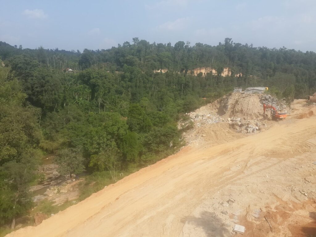
Roads are among the most damaging intrusions into wildlife landscapes because they bring fragmentation, speed, noise, light, and permanent access.
Someshwara Sanctuary and corridor proposals show why “small” posts still matter:
The combined records include a communication post proposal of 0.0186 ha in Balehalli village within Someshwara Sanctuary.
Members in one meeting specifically raised concerns about the possible impact of communication posts on birds.
In some cases, the committee asked for details on bird impact and beneficiary count before taking the matter forward.
That is important because it shows the wildlife risk was officially recognized.
What looks small in a file can still matter greatly in the real world when it enters a sanctuary, a corridor, or a sensitive wildlife landscape.
Rangayyanadurga Sanctuary should not be missed
Another Karnataka proposal that must not be left out is from Rangayyanadurga Sanctuary.
The file records 0.6996 ha for laying a water supply pipeline in Jadanakatte and Gurusiddapura villages, Jagaluru taluk, Davanagere district, in favour of Karnataka Neeravari Nigam Limited.
This is important because it shows that the pattern is not limited only to the Western Ghats or tiger reserves.
Even other wildlife sanctuaries are being drawn into infrastructure alignments.
Again, the diversion may look modest on paper. But the larger issue remains the same: protected wildlife land is being treated as available for utility entry.
Bukkapatna and Upper Bhadra Project show how a big project advances step by step:
One of the most important items in the combined material is the Upper Bhadra Project – Tumkur Branch Canal linked to Bukkapatna Sanctuary.
The proposal here was not full canal excavation itself, but detailed soil investigation along the canal alignment from Km 150.735 to Km 158.357 within the sanctuary.
The records say:
- the canal passes through Bukkapatna Sanctuary
- the sanctuary stretch is 7.622 km
- an earlier canal alignment had already been recommended by NBWL
- earlier proposal involved 51.32 ha of forest land
- present survey work involved invasive activities needed to prepare mitigation structures, plans, and estimates
This is extremely important because large projects do not begin only when digging starts. They move step by step through survey, soil testing, alignment work, and preliminary approvals.
That is exactly what these records show. A canal project advances through the clearance system even before the final large physical impact begins on the ground.
Water and electrification projects are repeatedly being used to enter forest land:
Many of the proposals are socially sensitive because they are linked to drinking water or electrification for rural and tribal habitations.
That makes them harder to oppose in a simple moral way.
But the documents still reveal a hard truth: public utility projects are repeatedly being used as the route through which protected forest land is entered.
This can be clearly seen in:
Sharavathi drinking water proposal for 325 households
multiple BRT drinking water proposals
Kollegal region water schemes across three protected areas
Zari water supply augmentation in BRT core area
Palar FHTCs in tiger corridor landscape
Rangayyanadurga water pipeline proposal
Honnavara-side water augmentation
Repeated water schemes linked to many villages and habitations in Chamarajanagar landscapes.
No one is saying people do not need water or electricity.
The real question is different:
Were all non-forest alternatives fully exhausted before protected wildlife landscapes were used?
From the combined records, there is no strong confidence that this was always done.
Missing Right of Way documents keep appearing
Another repeated warning sign across the combined notes is the issue of Right of Way claims without supporting documents.
This comes up again and again in relation to:
Cauvery-side electrification proposals
Sharavathi water pipeline proposals
Kollegal drinking water proposal
OFC proposals in Honnavar Division
OFC proposals in Kali-linked landscapes
telecom line proposals in Sharavathi and Kali
BRT water supply proposals
This matters because if the claimed legal basis of the route is not properly supported, then even recommending the proposal becomes questionable.
This is not a minor paperwork issue. It goes to the heart of how seriously these wildlife clearances are being examined.
Even conservation proposals do not seem to move quickly.
One of the few protection-oriented proposals in the combined material was the plan to declare a Conservation Reserve in Kalaburagi, covering part of notified forest land in Allur (B) village, Chittapur taluk.
The forest officials said the land had high conservation value, supported leopard habitat, and was suitable for declaration as a Conservation Reserve.
But the proposal was only deferred for a more comprehensive technical assessment.
This contrast matters.
Projects to use forest land keep moving through the system. But even a proposal meant to give stronger protection to wildlife habitat does not seem to move faster.
A few rejections happened but the larger trend is still dangerous
To be fair, not everything was approved.
Some proposals were rejected or not recommended, including:
- above-ground electricity line proposals in Kudremukh
- several core-area telecom / OFC proposals in Kali Tiger Reserve
- a BSNL communication post in BRT core area
- OFC routes in Anshi-Dandeli / Kali core landscapes
- the RVNL above-ground transmission line in the Castlerock Range
- the MESCOM aerial cable line in Kudremukh
Some proposals that were deferred include:
some MM Hills electrification cases
Bharti Airtel / Telephonic proposals in MM Hills and Kudremukh
some communication posts in corridor and sanctuary areas
the Conservation Reserve proposal in Kalaburagi
railway-related matters pending technical report
These rejections matter. They show that ecological danger was recognized in some of the most sensitive cases.
But the larger pattern still remains deeply troubling.
Because the majority of the overall pressure is still moving in one direction: into the forests.
Many proposals were recommended. Many were forwarded subject to NBWL approval. Many were kept active in the system. So, this is not a story of firm protection winning. It is a story of forests being repeatedly asked to adjust.
The damage is not only to trees
These records support a much larger criticism.
The damage is not only about hectares.
It is not only about the tree-felling count.
The documents themselves mention risks to:
wildlife movement
tiger corridors
elephant habitat
bird safety
slope stability
landslide-prone terrain
stream health
sedimentation of watercourses
man-animal conflict
habitat fragmentation
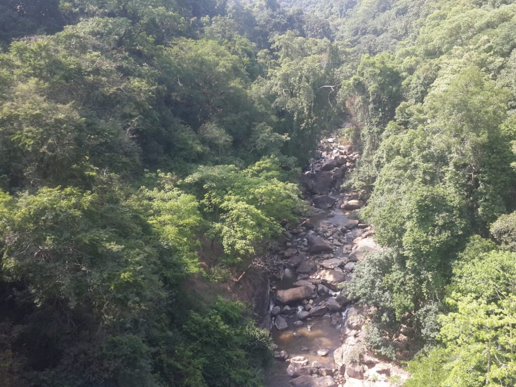
This is especially important for Karnataka because the State’s remaining forests are deeply tied to rivers, streams, slopes, rainfall patterns, and broader ecological stability.
When these forests are opened up, the damage does not stop with tree loss. It spreads into erosion, siltation, landslips, disturbed water systems, and weakened wildlife movement.
So, this is not only a forest story.
It is also a water story.
It is also a slope story.
It is also a bird story.
It is also a future survival story.
Karnataka’s forests are being ripped apart – not always in one dramatic act, but through a steady stream of approvals, recommendations, deferrals, upgrades, and repeated entries into protected landscapes.
A few projects were rejected.
But far too many were recommended, forwarded, or kept alive in the system.
That is what makes this so dangerous. Within a few years, at this pace, very little may remain truly intact.
Not because one single project destroyed everything.
But because the forests were slowly cut open by:
towers
telecom lines
OFC routes
drinking water pipelines
electrification works
road widening
railway doubling
power lines
canal survey works
repeated infrastructure “upgrades”
One small proposal at a time.
That is how a forest dies.
Not only through the axe.
But through the file.
And that is exactly what these Karnataka records reveal: a slow tearing apart of the State’s last remaining wildlife landscapes.
At the same time, one practical point must also be remembered. A few records suggest that keeping forest-dwelling communities on good terms can help conservation, because people living close to forests can also help protect them. At the same time, voluntary relocation is not a simple answer. One has to think realistically about the cost of land, the availability of suitable land outside forests, and whether proper rehabilitation is even possible. That is why a practical, humane, and honest approach is necessary.
(THE ABOVE WRITE-UP IS SOLELY THE AUTHOR’S OPINION & NOT OF GREEN MINUTE NEWS)